Geological Sites
Geosites
1.The granitoid gneiss (orthogneiss) of Hirano
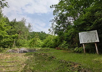
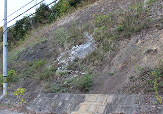
The orthogneiss of Hirano is a rock that is formed as blocks and surrounded by serpentinite. It has been designated as a natural monument by Mine City. The orthogneiss was formed when granite that makes up the oceanic crust metamorphosed at a high temperature approximately 430 million years ago. The granite that became this orthogneiss is different to the more common granite that is found in the continental crust, and the process by which the rock was exposed to the earth’s surface is unknown. There are thus many mysteries surrounding the orthogneiss of Hirano.
Geosites
2.The serpentinite of Hirano
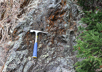
When peridotite that is distributed deep underground reacts with water, it turns into a rock called serpentinite. The rock is made lighter as a result of this reaction and rises to the surface of the earth. As it rises to the surface, the serpentinite mixes with orthogneiss. The rock is called “serpentinite” because of its smooth surface and snake-like patterns. It is often used as a concrete aggregate, and was mined in the past for the asbestos that can be found inside it.
Geosites
3.The basalt of Miyanobaba
In Miyanobaba, Mitō-chō, there are outcrops (where rocks are exposed) along the side of the road where basaltic rock from approximately 350 to 320 million years ago can be seen. Chemical analysis has shown that the rocks were formed by the eruption of an underwater volcano which created an elevated area on the ocean floor (a seamount). Coral reefs grew at the top and around the seamounts, which later became limestone.
Geosites
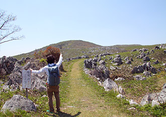
4.Mt Kanmuri
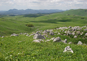
The inverted structure of the Akiyoshidai Karst Plateau can be seen on Mt Kanmuri (377 m). Many fossils of calcareous algae and types of marine sponges have been found on the surface of the limestone at the summit, which suggests that the limestone was once a reef where organisms lived. The summit provides a panoramic view of the karst plateau of Akiyoshidai, including the many limestone pillars to the north and the many dolines (cone-shaped sinkholes) to the south.
Geosites
5.Mt Kita
Mt Kita (367 m) is formed from limestone that dates back to approximately 320 to 280 million years ago. There are remains of iron ore mining on its north-western slope, and remains of trenches that were dug when Akiyoshidai Karst Plateau was used as a military training ground on its southern slope.
Geosites
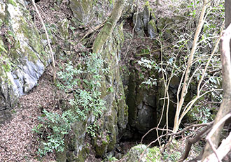
6.Kaerimizu
At Kaerimizu, limestone that dates back to approximately 300 to 260 million years ago is distributed along a doline. Different types of fusulina fossils and sedimentary structures can be seen at outcrops (where rocks are exposed). This is where Yoshiaki Ozawa, who was a geologist at the Tokyo Imperial University (the present-day University of Tokyo), discovered the inversion structure of geological layers. There is a spring at the bottom of Kaerimizu that never runs dry throughout the year.
Geosites
7.Mt Ryūgohō
Mt Ryūgohō (425.5 m) is the highest mountain on Akiyoshidai Karst Plateau. Along a fault in the mountain, you can see lines of minerals such as calcite and quartz which formed approximately 100 million years ago as a result of magmatic activity. There is crystalline limestone (marble) on the north-eastern slope of the mountain which contains gravel that holds fossils of brachiopods and fusulina.
Geosites
8.Chōjanishiki Quarry Ruins
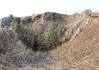
The Chōjanishiki Quarry Ruins are the remains of a former limestone quarry. This is one of the many sites in Akiyoshidai Karst Plateau where limestone that reacted to magmatic activity approximately 100 million years ago can be seen. The limestone has recrystallized as a result of magmatic activity, and has become a reddish crystalline limestone (marble).
Geosites
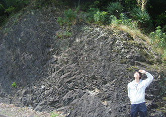
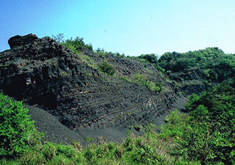
9.The chert of Kamisobara
Chert comes in many different colors, and the chert that is distributed across Kamisobara is black. Chert is a rock formed from the remains of plankton that have siliceous skeletons and shells which slowly accumulate on the sea floor and turn to rock. The chert here shows that the remains of these plankton accumulated in the deep, wide ocean around the coral reef which became the basis of the Akiyoshidai Karst Plateau limestone.
Geosites
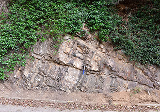
10.The sandstone of Ayagi
When sand and mud flow down the continent along the coast, they gather at the bottom of the sea and become rock layers. When dense sand and mud flow down the slopes at the bottom of the sea and accumulate, they form sediments. These sediments are known as turbidite and retain the flow patterns which show how they flowed down the slopes.
Geosites
11.The limestone block-containing mudstone of Higashi-Shibukura
A layer of mudstone that contains a large limestone block several meters in diameter can be seen at Higashi-Shibukura. This limestone was formed from a coral reef in the distant, southern ocean. This block of limestone was carried to the continent on the oceanic plate as part of a large lump which broke apart when it collided with the continent, and then became embedded in mudstone. Rocks such as this where multiple types of rocks change shape and mix together are called mélange.
Geosites
12.The pebbly mudstone of Tsunemori
This rock was created as rocks of various sizes and types that slid down the slopes at the bottom of shallow seas changed shape and mixed together. In scientific terms, this would be called a mélange that came about through a submarine landslide. This mélange was formed towards the top half of Akiyoshidai Karst Plateau’s limestone after the limestone had attached itself to the continent through the movement of plates.
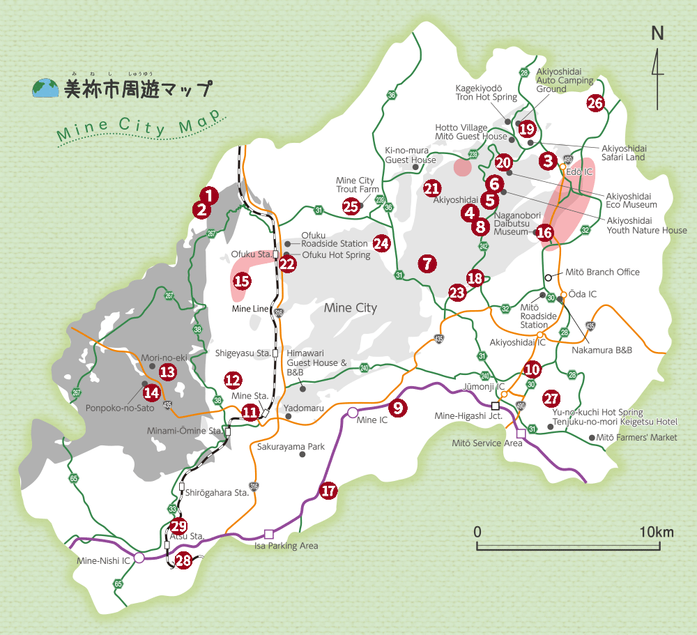
Geosites
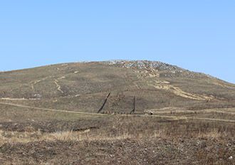
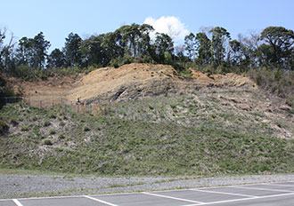
13.Momonoki Strip Mine Ruins
The Momonoki Strip Mine is where coal was mined from the surface of the ground between 1966 and 1970.
※There is no public access to this geological site
Geosites
14.The fossiliferous siltstone of Okubata
This rock layer was formed between 230 and 220 million years ago and contains many fossils of insects and plants from that period, including the triassoblatta okafujii, the oldest cockroach fossil from Japan. It is believed that a mass extinction of all living things occurred in the period before this layer was formed. This layer, therefore, tells us about the creatures that regained life and flourished after the mass extinction.
Geosites
15.The granite of Ofuku
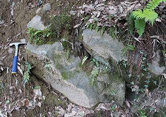
When magma that creates granite enters an area with limestone, it heats up the limestone in its surrounding area and turns it into marble. The magma then becomes granite after it has slowly cooled and hardened. In the same way, when granitoid magma enters an area with coal it carbonizes the coal. Carbonized coal emits little smoke. The heat of Ofuku’s granite created marble as well as anthracite, a type of coal that does not produce much smoke.
Geosites
16.Naganobori Skarn Deposit (Strip Mine Ruins)
This is a skarn deposit that was formed through the reaction of the Carboniferous to Permian-period limestone of Akiyoshidai Karst Plateau with the late Cretaceous-period magma. Naganobori is the only mine where chemical analysis has proven that its copper was used to construct the Great Buddha of Nara.
Geosites
17.The Great Rocks of Magura
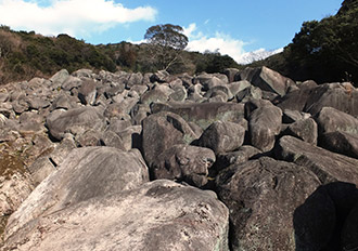
‘The Great Rocks of Magura’ is an area that is completely covered by huge rocks, up to 7 m in length. These rocks were formed approximately 100 million years ago from magma that slowly cooled and hardened. At first glance it may look as if the rocks flowed down the slope, but in reality the rocks were formed by weathering and erosion that occurred along the cracks in the rocks.
Geosites
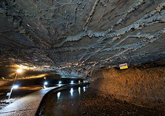
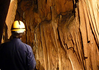
18.Akiyoshidō Cave
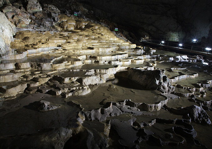
Akiyoshidō Cave is 11 km long (second longest in Japan) and is the largest limestone cave in Japan in terms of the space inside. The cave is located downstream of a karst groundwater system and a large quantity of water flows through its underground river. Many cave formations such as stalactites can be seen inside the cave. It is inhabited by creatures that are specific to caves, such as Shikoku yokoebi (Pseudocrangonyx shikokunis), as well as bats that appear between May and August. 453 limestone caves have been discovered so far beneath the Akiyoshidai Karst Plateau. In addition to Akiyoshidō Cave, Kagekiyodō Cave (Kagekiyo Hole) which extends horizontally and Taishōdō Cave which has a net-like structure are open to the public.
- Opening hours: 8:30-16:30 (open all year)
- Entry fees: Senior high school student or older: 1,300 yen; Junior high school student: 1050 yen; Elementary school student: 700 yen; Pre-school or younger: free
- Inquiries: Akiyoshidai Tourist Information Center (TEL) +81 (0)837-62-0305
Geosites
19.Kagekiyo Hole (Kagekiyodō Cave)
Kagekiyo Hole is a tunnel-like cave approximately 1.5 km long with openings at both ends and a river that flows inside. Today, however, visitors cannot pass through the cave. Patterns that were formed as water dissolved the limestone and fossils of coral and sea lily can be seen on the walls of the cave. The cave begins with the tourist course, which is followed by a 400 m-long exploration course where visitors walk through the cave with only a torch to light the way.
- Opening hours: 8:30-17:15 (last entry 16:30 / open all year)
- Entry fees: Junior high school student or older: 1,100 yen; Elementary school student: 600 yen; Pre-school or younger: free
- Exploration course admission fee: 300 yen (including rental fee for helmet and boots)
- Inquiries: Kagekiyodō Cave Information Center (TEL) +81 (0)8396-2-2201
Geosites
20.Taishōdō Cave
Taishōdō Cave, which has a height difference of 100 m in total, is a three-dimensional cave with roughly three tiers. Various traces of the developmental stages of limestone caves can be seen in this cave. An investigation that was conducted in 2014 revealed that Taishōdō Cave is connected underground to Inugamori Hole, which increased its length to approximately 2,000 m and made Taishōdō Cave the third longest cave in Akiyoshidai Karst Plateau.
- Opening hours: 8:30-17:15 (last entry 16:30 / open all year)
- Entry fees: Junior high school student or older: 1,100 yen; Elementary school student: 600 yen; Pre-schooler or younger: free
- Inquiries: Taishōdō Cave Information Center (TEL) +81 (0)8396-2-0605
Geosites
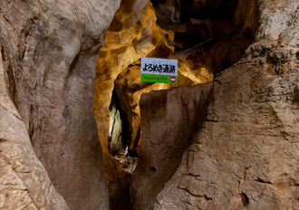
21.Nakaodō Cave
Nakaodō Cave is a limestone cave that is composed of the entrance that leads to a vertical hole, the central section which is also the lowest part of the cave, and the deepest part of the cave beyond this section. In 1921, some children and teachers from the local school discovered extremely beautiful stalactites in the deepest part of the cave. This led the cave to be registered as a National Natural Monument two years after the discovery. In order to preserve the stalactites, the cave is not currently open to the public.
Geosites
22.Ofukudō Cave
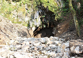
Ofukudō Cave is a hole that was formed as limestone dissolved, and a river flows into it. This area is called Irimizu (“water enters”) because of this land form, which is known as a sinkhole. The water that flows into the cave passes through the limestone cave, exits at Shiramizu Pond and flows towards the Kotō River.
Geosites
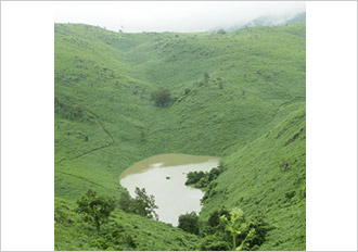
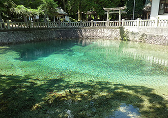
23.Suijin Pond (Blue Pond)
Suijin Pond is located on the edge of the limestone of Akiyoshidai Karst Plateau. The water of the pond springs up from the limestone area. Rivers that flow along the surface of the ground are rare in limestone areas, so spring water like this is an extremely valuable resource for farmers. There is a site for worshipping a water god by the pond.
Geosites
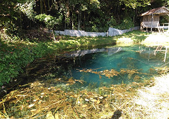
24.The hole of Shiramizu Pond (Spring Water)
Shiramizu Pond is located at the foot of the mountains in the north-east of Western Akiyoshidai Karst Plateau. The pond is called Shiramizu Pond (“white water pond”) because the water that springs up is slightly cloudy. The abundant spring water that flows all year round contains a large amount of calcium and bicarbonate ion because it dissolves limestone as it springs up. The water has been used for farming in the surrounding areas since ancient times.
Geosites
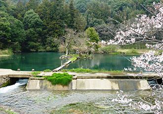
25.Beppu Benten Pond
Beppu Benten Pond is located in the compounds of Itsukushima Shrine and has a circumference of approximately 40 m and a depth of approximately 4 m at its center. It is thought that the water of the pond is the groundwater that flows from Mt Hanao to the north-west of the pond which springs up along a fault. The water has been used by local people since ancient times for domestic and agricultural use, and is used today to farm rainbow trout.
Geosites
26.Mitō Waterfall
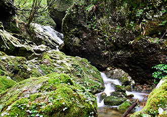
Mitō Waterfall is made up of five consecutive waterfalls where the water flows down five steps, and is 11 m tall. In English a distinction is made between a cascade, where water flows down several steps such as this waterfall, and a fall where a large quantity of water flows down vertically. A type of volcanic rock called dacite can be seen at waterfalls in this area. The steps in this waterfall may or may not have been produced by elements such as faults in the dacite.
Geosites
27.The outcrop of the fault of a tectonic line in Saigatao, Mana
This is where a stratum boundary (fault) that stretches for approximately 20 km in the north-east to south-west direction from Ayagi in Mitō-chō, Mine-shi, to around Higashikibe, Ube-shi, can be seen above ground. An area where the ground became misaligned 100,000 years ago due to the movement of faults can be seen here. Because of this, it has been suggested that the faults may be active faults that have the potential to move again and cause an earthquake in the future.
Geosites
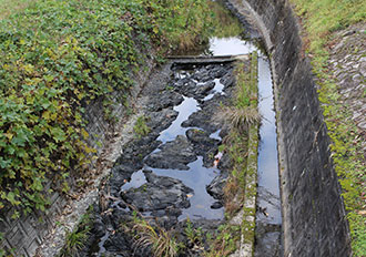
28.The potholes of Atsu (The ogre’s furnace)
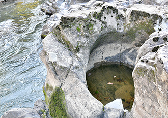
More than 50 circular holes (potholes) of various sizes that have developed in the bedrock can be found along the banks of the Asa River. Numerous cracks have developed on the surface of the gentle slope of the sandstone layer, and the potholes can be seen along those cracks. It is known as “The ogre’s furnace”, based on the legend that an ogre family used it for bathing. There is also a depression which is known as an ogre’s footprint.
Geosites
29.The autochthonous limestone of Atsu
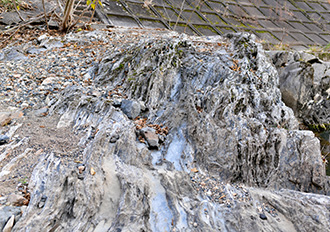
This limestone was formed 30 to 240 million years ago. It was formed around the same time as the Mine Group, which includes the coal bed of Ōmine Coalfield. The limestone at this site was formed by the accumulation of coral and other materials in the shallow ocean along the continental margin. Sandstone and mudstone are embedded into the limestone, creating a striped pattern. There are many depressions on the surface of the bedrock that are exposed along the riverbank, which were created as the limestone dissolved. Since the characteristics of the limestone resemble the karst landscape of Akiyoshidai, it is thought that this site was once a riverbed.